http://news.nationalgeographic.com/news/2010/08/100816-fires-thunderstorms-thunder-clouds-volcanoes-science-weather-russia/
Intense fires have the power to generate dirty thunderclouds that may be influencing the climate, scientists have discovered.
Like volcanoes, the dirty, fire-induced thunderstorms, or pyrocumulonimbus storms (pyroCbs), can funnel smoke and particulates high into the stratosphere, experts announced Friday at an American Geophysical Union meeting in Foz do Iguaçu, Brazil.
The high-flying smoke palls created by the so-called pyrocumulonimbus storms (pyroCbs) may be having unknown effects on Earth's climate, such as warming or cooling the atmosphere, the scientists added.
And the fire-started storms aren't just figments of a climate model. Recent satellite images, for instance, show that the forest fires currently raging in Russia (pictures) are generating several pyrocumulonimbus storms of unprecedented size, according to Michael Fromm, a meteorologist at the U.S. Naval Research Laboratory in Washington, D.C.
(Also see "Planes Create Weird Clouds—And Snow, Rain Fall Out.")
Dirty Clouds Long Mistaken for Volcanic Ash
Pyrocumulonimbus clouds had long been mistaken for volcanic ash clouds, but Fromm and colleagues' new survey of satellite images dating back to 1979 has definitively linked them to especially intense forest fires called crown fires, the team says.
"It's when the fire sweeps from treetop to treetop without necessarily working its way down the trunks," said Nathaniel Livesey, an atmospheric scientist at NASA's Jet Propulsion Laboratory in California, who worked on the survey.
The intense, rising smoke and heat of a crown fire can cause storm clouds to form—clouds that are typically bigger, taller, and darker than normal thunderstorm clouds.
Like natural smokestacks, the pyrocumulonimbus clouds absorb the fire's smoke and aerosol particles and funnel the pollutants as high as 11 miles (17 kilometers) into the upper atmosphere, where they exit the clouds and drift far and wide.
"An entire hemisphere can be polluted by an individual pyroCb ... and the smoke and pollutants can linger for several months," the Naval Research Laboratory's Fromm told National Geographic News.
The fire-started clouds are abnormal in other ways too. For example, while they can produce thunder and lightning and even tornadoes, pyroCbs rarely, if ever, create rain.
"That's because of the unique ingestion of so many smoke particles into the thunderstorm," From said.
By preventing water molecules from coming together, "the smoke essentially cuts off the precipitation process, so you get very violent storms without much rain," he said.
Furthermore, unlike normal thunderclouds, the fire-born clouds don't drift. They remain tethered to the blazes from which they were born.
Tuesday, December 14, 2010

Cancun Climate Summit Yeilds Deals
http://www.bbc.co.uk/news/science-environment-11975470
UN talks in Cancun have reached a deal to curb climate change, including a fund to help developing countries.
Nations endorsed compromise texts drawn up by the Mexican hosts, despite objections from Bolivia.
The draft documents say deeper cuts in carbon emissions are needed, but do not establish a mechanism for achieving the pledges countries have made.
Some countries' resistance to the Kyoto Protocol had been a stumbling block during the final week of negotiations.
However, diplomats were able to find a compromise.
Delegates cheered speeches from governments that had caused the most friction during negotiations - Japan, China, even the US - as one by one they endorsed the draft.
BBC environment correspondent Richard Black said the meeting did not achieve the comprehensive, all-encompassing deal that many activists and governments want.
But he said it was being "touted as a platform on which that comprehensive agreement can be built".
Click to play
Click to play
Advertisement
European Climate Commissioner Connie Hedegaard said the deal was substantial and covered several issues
Mexico's President Felipe Calderon said the summit had allowed leaders to "glimpse new horizons" where countries had the "shared task to keep the planet healthy and keep it safe from [humans]".
UN talks in Cancun have reached a deal to curb climate change, including a fund to help developing countries.
Nations endorsed compromise texts drawn up by the Mexican hosts, despite objections from Bolivia.
The draft documents say deeper cuts in carbon emissions are needed, but do not establish a mechanism for achieving the pledges countries have made.
Some countries' resistance to the Kyoto Protocol had been a stumbling block during the final week of negotiations.
However, diplomats were able to find a compromise.
Delegates cheered speeches from governments that had caused the most friction during negotiations - Japan, China, even the US - as one by one they endorsed the draft.
BBC environment correspondent Richard Black said the meeting did not achieve the comprehensive, all-encompassing deal that many activists and governments want.
But he said it was being "touted as a platform on which that comprehensive agreement can be built".
Click to play
Click to play
Advertisement
European Climate Commissioner Connie Hedegaard said the deal was substantial and covered several issues
Mexico's President Felipe Calderon said the summit had allowed leaders to "glimpse new horizons" where countries had the "shared task to keep the planet healthy and keep it safe from [humans]".
Anesthetic Gases Heat Climate as Much as One Million Cars Do, New Research Shows
From the ScienceDaily.com website: "When doctors want their patients asleep during surgery, they gently turn the gas tap. But anesthetic gasses have a global warming potential as high as a refrigerant that is on its way to be banned in the European Union. Yet there is no obligation to report anesthetic gasses along with other greenhouse gasses such as carbon dioxide, refrigerants and laughing gas."
Read the full article here:
http://www.sciencedaily.com/releases/2010/12/101203081644.htm
Read the full article here:
http://www.sciencedaily.com/releases/2010/12/101203081644.htm
Lee Hotz: Inside an Antarctic Time Machine
Also from the ted.com website: "Science columnist Lee Hotz describes a remarkable project at WAIS Divide, Antarctica, where a hardy team are drilling into ten-thousand-year-old ice to extract vital data on our changing climate."
Watch the video here:
lee_hotz_inside_an_antarctic_time_machine
Watch the video here:
lee_hotz_inside_an_antarctic_time_machine
David Keith's Unusual Climate Change Idea
From the Ted.com website, "Environmental scientist David Keith proposes a cheap, effective, shocking means to address climate change: What if we injected a huge cloud of ash into the atmosphere to deflect sunlight and heat?"
Watch his lecture here:
http://www.ted.com/talks/david_keith_s_surprising_ideas_on_climate_change.html
Watch his lecture here:
http://www.ted.com/talks/david_keith_s_surprising_ideas_on_climate_change.html
Residents Blame City For Constant Floods
www.weather.com reports that, "Historic floods in March actually changed the course of the Woonasquatucket river in Cranston, Rhode Island. Now, homeowners say the city hasn't done enough to solve the problem."
Watch it here: http://www.weather.com/outlook/videos/caught-on-cam-dramatic-water-rescue-19034#19037
Watch it here: http://www.weather.com/outlook/videos/caught-on-cam-dramatic-water-rescue-19034#19037
31ft Polish Snowman

By Daily Mail Reporter
Last updated at 5:57 PM on 12th December 2010
It's Frosty, super-sized.
This 31-foot behemoth - dubbed 'Milocinek' - is casting a long, frigid shadow over Trzebnica, Poland.
A group of 'bored' Poles started building him one day - and then decided they would just keep going.
Six days later, they hunted down a barrel for a hat and a traffic cone for a nose, and their work was done.
The resulting Goliath of a snowman stands on eye-level with surrounding two-storey homes, and dwarfs passing cars.
The snowman was completed Friday near the town of Trzebnica in southwestern Poland.
A Polish newspaper's website reported Saturday that the snowman's builders believe Milocinek is the largest snowman built in Poland since winter weather set in more than a week ago.
Other observers go further - suggesting he may well be the largest snowman in the world.
But with a major storm dumping two inches of snow an hour on America's mid-west last night, and thousands of children being held home from school, that record may not last for long.
Read more: http://www.dailymail.co.uk/news/article-1337926/Is-worlds-biggest-snowman-Bored-Poles-build-31ft-behemoth-traffic-cone-nose.html#ixzz186rephcE
Flash new space tools to monitor lightning
13 December 2010 Last updated at 12:55 ET
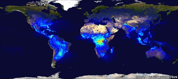
A US space agency lightning detector circles the Earth in a low-orbit. Its map of lightning frequency shows that places in Africa experience the greatest number of strikes
Cameras to detect lightning on Earth are to be placed high up in space by the US and Europe this decade.
Meteorological agencies already monitor lightning from the ground, and American instruments also fly in a low orbit.
But the addition of systems that sit and stare at the Earth from 36,000km should deliver a wealth of new data to improve warnings about imminent storms.
This will have key benefits for the aviation sector in particular, allowing it to route planes more safely.
"Lightning is a very good proxy for severe weather. In fact, it is a lead indicator - you often get lightning just before you get heavy rain, hail and even big gusts of wind," explained Dr Jochen Grandell from the European Organisation for the Exploitation of Meteorological Satellites (Eumetsat).
"For lightning safety as well - you can see active areas. Not all storms produce lightning and that is important information for aviation," he told BBC News.
Dr Grandell will be speaking this week at the American Geophysical Union (AGU) Fall Meeting, the largest gathering of Earth scientists in the world.
He will be describing the novel Lightning Imager that will go on Europe's next generation of Meteosats from late 2017. They will be the first geostationary spacecraft operated by Eumetsat to carry such an instrument. The Americans, too, plan lightning imagers for their Goes-R and Goes-S meteorological platforms.
The European imager, at a very basic level, is like a high-speed video camera. It will view the disc of the Earth from high above Africa, and stream information on lightning to weather forecasters in about a minute of discharges being detected. This will assist greatly with what meteorologists call "nowcasting" - the ability to make very short range, local forecasts of intense storm activity.
More than 2,000 thunderstorms are in play throughout the world at any one time, producing on the order of 100 flashes per second. Land areas get more lightning than the ocean, with tropical Africa experiencing the most strikes.
The Meteosat instrument will detect cloud-to-cloud and cloud-to-ground lightning. It will see the discharges as a rapid brightening of the cloud tops. This rather diffuse light, observed in the near-infrared, will give location information down to about 10km.
"We'll see not just the lightning in night-time conditions when you can imagine it's quite simple, but we'll also be seeing it in daylight when the cloud is illuminated by the Sun overhead. Technically, that's quite a challenge," said Dr Grandell.
Viewed from above the clouds by the shuttle, lightning appears as diffuse blobs
Meteorological agencies such as the British Met Office already use very effective ground systems to detect lightning. The UK has a system called ATDNet which senses a discharge from its radio frequency emission. Radars can also provide lightning information, and these are commonly used near airports to warn of approaching severe weather that might force authorities to divert or even ground planes.
The Eumetsat system in geostationary orbit will be complementary to the terrestrial systems, with one of the imager's major contributions expected to be the uniformity of its coverage - the idea that the one instrument sees lightning over the full disc of the Earth.
This will help climate researchers, for example, to develop very good statistics on the frequency of lightning over time.
"As soon as we have a number of years of data, we might be able to assess the impact of climate change on thunderstorm activity," said Dr Rolf Stuhlman, the Eumetsat MTG programme scientist.
Continue reading the main story
METEOSAT - BIGGER, BETTER
Europe's 1st Meteosat imaging spacecraft (800kg) was launched in 1977
Today, the 2-tonne Meteosat 8 & 9 spacecraft help produce Europe's forecasts
The planned 3rd generation imager will be a 3-tonne satellite; it should enter service in 2018
MTG (above) adds a second platform: a sounding satellite to sense the different atmospheric layers
Consortium wins big weather prize
"Climate is always something which is global and we will not be looking global, this is true. But there will be lightning imagers on the American Goes-R and Goes-S satellites, and there are plans also for Chinese geostationary satellites. So we can expect soon to have all these lightning imagers in the global agreement [on data sharing]."
Atmospheric chemists are also fascinated by lightning because its energy plays a significant role in turning the "unreactive" nitrogen in the air into the "reactive" forms such as nitrogen oxides. These can catalyse the production of ozone, which near the ground is an irritant to the human respiratory system and is damaging to plant health.
And another potential benefit would be in helping to improve the models used to forecast where forest fires might start as a result of lightning strikes.
The 3.4bn-euro (£2.8bn) Meteosat Third Generation (MTG) project is one of the most complex space endeavours ever undertaken in Europe.
Its suite of instruments spread across two satellite platforms should bring a step change in capability.
When the operational system is in place, it will be delivering something like 250-300Mbps of data to Eumetsat headquarters in Darmstadt, Germany. That information then has to be processed and distributed to the continent's national meteorological agencies so they can produce constantly updated forecasts for their citizens.
Jonathan.Amos-INTERNET@bbc.co.uk
Stormy weather in Egypt kills at least 18

13 December 2010 Last updated at 14:08 ET
At least 18 people have died in accidents caused by storms in Egypt, the country's state media reported.
Dozens more were injured in road accidents and when buildings collapsed after being battered by sandstorms and rain.
Fierce winds, heavy rains and snow have lashed eastern Mediterranean and Middle Eastern countries for several days.
The storms have sunk a ship off the Israeli coast, closed ports and disrupted shipping in the Suez Canal.
Rescue workers pulled the bodies of six workers out of the debris of a factory building that had collapsed in the northern city of Alexandria on Sunday.
One man who had been wounded in the accident died of his injuries on Monday, bringing the overall death toll of the collapse to 10.
Rescue workers were still searching for more workers believed to be trapped under the rubble.
Officials had denied earlier reports that the collapse of the textile factory was related to the bad weather.
But the state-owned al-Ahram newspaper said the heavy rains had damaged the structure of the factory.
The paper reported that several other buildings had collapsed across Egypt, causing more deaths.
Sandstorms, rain and poor visibility also led to a number of road accidents which killed and injured dozens, officials said.
The storms have ended a long drought in Lebanon, Syria and Israel and came just a week after more than 40 people died in a forest fire near Israel's northern port of Haifa.
At the weekend, shipping was delayed through the Suez Canal and most Egyptian ports, both on the Red Sea and the Mediterranean - including the country's largest at Alexandria - were closed, with winds reaching speeds of up to 60km/h (37mph).
Waves of up to 10m (33ft) battered coasts, damaging fishing boats in Lebanon. In Syria, snow blanketed the streets of the capital, Damascus, and closed roads.
Scottish government outlines weather response changes

Scottish ministers have announced a series of changes to improve its response to severe winter weather, amid warnings of more heavy snow.
Extra salt and grit will be stored at key locations, while plans have been put in place to hold lorries using the roads, if the snow and ice hits.
The move came after the row over the handling of last week's severe weather which saw the busiest roads gridlocked.
The Met Office has warned of heavy snow across Scotland on Thursday and Friday.
The Scottish government announced measures to set up a new severe weather group, comprising police, trunk road operating companies, transport officials and ScotRail.
Ministers also announced a six-point action plan for coping with further problems, to:
Store extra salt and grit at key locations on the national trunk road network for quicker access.
Use traffic management resources to enable diversions where necessary.
Adapt vehicles, such as landscaping vehicles, for clearing snow.
Remove trunk road and motorway central barriers, allowing easy access to blocked or broken down vehicles if necessary.
Work with the police on holding, or "stacking" lorries on the roads, if conditions deteriorate, to keep traffic moving.
Provide blankets and other supplies to central Scotland's Trunk Road Incident Support Service.
The plans were announced as Finance Secretary John Swinney was questioned by the Scottish Parliament's transport committee.
But he warned: "We have to accept in winter weather weather that there will be times where its just not possible for us to function normally and do all we can to try to avoid that, but sometimes accept that services may not be able to function."
Lib Dem transport spokeswoman Alison McInnes said the action was "better late than never," adding: "These are all things the previous transport minister could have done."
The Tories' Jackson Carlaw, said: "Scottish Conservatives welcome these measures in so far as they go, but believe yet more reliable systems for informing the public of the prevailing facts are urgently required."
A heavy snowfall last week - which appeared to take the authorities by surprise - caused the closure of the M8, M9 and A80, as well as gridlock on many other routes across Scotland.
Thousands of vehicles were abandoned and hundreds of people were stuck in their cars overnight, while the M8 was closed for two days between Edinburgh and Glasgow.
The problems led to the resignation of Stewart Stevenson as transport minister, to be replaced by Keith Brown.
Snow storm snarls Midwest: Is US facing another extreme winter?

By Patrik Jonsson, Staff writer / December 13, 2010
Atlanta
The driving early snowstorms and piercing cold winds blasting the Midwest, South, and East Coast – throwing commutes, air traffic, and football schedules into chaos – are the result of poorly understood atmospheric dynamics that may upset predictions of a milder winter for the eastern half of the US.
Scientists at the University of Wisconsin in Madison are among those trying to understand the mysterious interplay between Pacific and North Atlantic weather phenomena that threaten to dunk the Eastern US into a second year in a row of 1970s-style blizzards and cold snaps.
"At this point, this winter looks similar to last winter," says Jonathan Martin, an atmospheric scientist at Wisconsin. "The next question is, why does it look similar, and we're currently not in a position to say definitely what's going on. There are some interrelationships between big pieces of circulation anomaly that feed into one another, including an anomalous pattern over Greenland that's tied into convection in the tropical Pacific Ocean.
Scientists speculate that heat released from storms racing up the US East Coast toward the Labrador Sea may be feeding the so-called North Atlantic Oscillation – nicknamed "The Greenland Block" – in ways that are not yet understood. The region of high pressure over Greenland has pushed huge troughs of Canadian air into the US, causing the fifth biggest snow storm on record in Minneapolis over the weekend and now threatening Orlando, Fla., with 20 degree F temperatures.
The atmospheric upset has had the opposite effect on parts of the West, where cities like Long Beach, Calif., and Phoenix saw record high temperatures Monday.
The snow storm snarled US air traffic in the Midwest, shut down dozens of school districts, including Minneapolis and St. Paul, and led to major commuting problems across the region. The storm played a role in at least six deaths and sparked the first weather-related rescheduling of an NFL football game since hurricane Katrina hit New Orleans in 2005 when the inflatable roof of the Minneapolis Metrodome collapsed early Sunday morning under the weight of two feet of snow.
Last winter, the US reported snow coverage in nearly all 50 states in December. That anomaly led to unusual January freezes in the South and several "Snowmageddon" events in the mid-Atlantic, all of which Accuweather meteoreologist Joe Bastardi likened to "the great winters of the '60s and '70s."
Mr. Bastardi predicted earlier this fall that the East Coast will "be granted a reprieve" from the kind of major storms that buffeted the region last winter. In fact, he noted that a fast start to winter in the East could lead to a major thaw in January.
Meteorologists have also predicted greater-than-normal swings between the season's coldest and hottest days, creating what Mr. Bastardi dubbed "The Wintry Battle Zone."
But the pre-Christmas "snow blitz" in the upper Midwest, added to the near-zero wind chills in the South, continue to confound atmospheric scientists like Mr. Martin, who is not keen to make a call on how the Winter of 2011 will pan out.
"Given our level of ignorance about what's going on, we don't want to compound that with a level of arrogance by saying we know what's going to happen in a month," he says.
Outrageous Weather Myths Debunked
by Jaime McLeod | Monday, November 9th, 2009
For millennia, our ancestors relied on popular lore to predict the coming weather. Some of these, like the color of the sky at night, or the position of the leaves on a tree, have some basis in reality. Others, like the following, are simply outrageous.
If a rooster crows at night, there will be rain
by morning.
Actually, roosters crow whenever they want, day or night. The idea that roosters crow only at dawn is a misconception. The only reason roosters rarely crow at night is because they are diurnal animals that sleep at night. If a rooster does crow at night, any number of factors could be to blame. The animal could be sick, he may sense a predator, or he may just be feeling a bit antsy. Studies show many animals can sense bad weather
, and it may be that some roosters do crow if rain is on the way, but the correlation certainly isn’t as cut and dry as this myth suggests.
Pigs gather leaves and straw before a storm.
Like many other animals, domestic pigs possess a nesting instinct, passed down to them from their wild ancestors. Gathering leaves, straw, and other soft materials is just an outgrowth of that instinct. In some pigs, particularly sows, this instinct may be stronger than in others. Regardless, the weather does not play any known role in the timing of when any given pig will exhibit this behavior.
When dogs eat grass, you can expect a severe storm.
Nearly every dog eats a little grass at some point, and some dogs eat it as often as they can get it. The timing of when a dog eats grass, or how much, has to do with evolution, and with the individual dog. Dogs evolved as omnivores and scavengers. They eat both meat and vegetation, and historically found their food wherever they could get it. In the wild, dogs would have eaten grass regularly to supplement their nutrition. In addition, grass probably tastes good to most dogs, like a fresh salad to humans. Many dogs will also eat grass when they have an upset stomach. Because most healthy dogs can eat grass without throwing it back up, some veterinarians believe that the texture of grass helps to induce vomiting when a dog is already feeling nauseated. None of this, of course, has anything at all to do with the weather.
Birds on a telephone wire predict the coming of rain.
Not exactly. If you live in an area with enough birds and enough wires, chances are you will see birds roosting on the wires at just about any time of the day or night. There is absolutely no known connection between this behavior and the weather. However, birds in migration will often “stop over” in an area to wait out a bad storm in their path. If you notice a sudden increase in the number of birds in your town – whether they’re on telephone wires or not – then it could well mean that a downpour is on the way.
A falling meteor predicts fair weather.
“Meteors” are just a name for debris from space that get caught in the Earth’s atmosphere and burn up from the friction. Several meteors enter our atmosphere every hour. At several times each year, during named annual meteor showers, you can see dozens of “shooting stars” per hour. But if you watch carefully enough, you can typically spot at least one or two sporadic meteors during any given hour of any night. Though the number of meteors that fall is completely independent of the weather, there may be a grain of truth to this myth. Meteors, like stars and planets, are often visible with the naked eye, but are best viewed when the sky is clear. Overcast conditions, which often mean rain is on the way, certainly make it more difficult to see meteors, or much of anything else in the sky.
If salt pork turns sour, then be ready for a shower.
Like most superstitions, this saying was coined long before humans knew the scientific reasons for various natural phenomena. These days, of course, we know that bacteria, and not weather, is the reason meat spoils. The reason this myth specifically mentions salt pork is that, prior to the invention artificial preservatives or electric refrigeration, food was routinely preserved with salt. Unlike untreated meat, pork cured in brine will keep for several months or more. Because of its long shelf life, salt pork was generally eaten long before it had a chance to spoil. If left untouched for too long, though, even the best-preserved foods will eventually sour. If the timing of the spoiled meat’s discovery happened to coincide with a rain shower at one time or another, it was due to nothing more than chance.
Want more weather lore? Find out if cows lie down when it’s about to rain or whether crickets chirps can act as natural thermometers.
http://www.farmersalmanac.com/weather/2009/11/09/outrageous-weather-myths-debunked/
For millennia, our ancestors relied on popular lore to predict the coming weather. Some of these, like the color of the sky at night, or the position of the leaves on a tree, have some basis in reality. Others, like the following, are simply outrageous.
If a rooster crows at night, there will be rain
by morning.
Actually, roosters crow whenever they want, day or night. The idea that roosters crow only at dawn is a misconception. The only reason roosters rarely crow at night is because they are diurnal animals that sleep at night. If a rooster does crow at night, any number of factors could be to blame. The animal could be sick, he may sense a predator, or he may just be feeling a bit antsy. Studies show many animals can sense bad weather
, and it may be that some roosters do crow if rain is on the way, but the correlation certainly isn’t as cut and dry as this myth suggests.
Pigs gather leaves and straw before a storm.
Like many other animals, domestic pigs possess a nesting instinct, passed down to them from their wild ancestors. Gathering leaves, straw, and other soft materials is just an outgrowth of that instinct. In some pigs, particularly sows, this instinct may be stronger than in others. Regardless, the weather does not play any known role in the timing of when any given pig will exhibit this behavior.
When dogs eat grass, you can expect a severe storm.
Nearly every dog eats a little grass at some point, and some dogs eat it as often as they can get it. The timing of when a dog eats grass, or how much, has to do with evolution, and with the individual dog. Dogs evolved as omnivores and scavengers. They eat both meat and vegetation, and historically found their food wherever they could get it. In the wild, dogs would have eaten grass regularly to supplement their nutrition. In addition, grass probably tastes good to most dogs, like a fresh salad to humans. Many dogs will also eat grass when they have an upset stomach. Because most healthy dogs can eat grass without throwing it back up, some veterinarians believe that the texture of grass helps to induce vomiting when a dog is already feeling nauseated. None of this, of course, has anything at all to do with the weather.
Birds on a telephone wire predict the coming of rain.
Not exactly. If you live in an area with enough birds and enough wires, chances are you will see birds roosting on the wires at just about any time of the day or night. There is absolutely no known connection between this behavior and the weather. However, birds in migration will often “stop over” in an area to wait out a bad storm in their path. If you notice a sudden increase in the number of birds in your town – whether they’re on telephone wires or not – then it could well mean that a downpour is on the way.
A falling meteor predicts fair weather.
“Meteors” are just a name for debris from space that get caught in the Earth’s atmosphere and burn up from the friction. Several meteors enter our atmosphere every hour. At several times each year, during named annual meteor showers, you can see dozens of “shooting stars” per hour. But if you watch carefully enough, you can typically spot at least one or two sporadic meteors during any given hour of any night. Though the number of meteors that fall is completely independent of the weather, there may be a grain of truth to this myth. Meteors, like stars and planets, are often visible with the naked eye, but are best viewed when the sky is clear. Overcast conditions, which often mean rain is on the way, certainly make it more difficult to see meteors, or much of anything else in the sky.
If salt pork turns sour, then be ready for a shower.
Like most superstitions, this saying was coined long before humans knew the scientific reasons for various natural phenomena. These days, of course, we know that bacteria, and not weather, is the reason meat spoils. The reason this myth specifically mentions salt pork is that, prior to the invention artificial preservatives or electric refrigeration, food was routinely preserved with salt. Unlike untreated meat, pork cured in brine will keep for several months or more. Because of its long shelf life, salt pork was generally eaten long before it had a chance to spoil. If left untouched for too long, though, even the best-preserved foods will eventually sour. If the timing of the spoiled meat’s discovery happened to coincide with a rain shower at one time or another, it was due to nothing more than chance.
Want more weather lore? Find out if cows lie down when it’s about to rain or whether crickets chirps can act as natural thermometers.
http://www.farmersalmanac.com/weather/2009/11/09/outrageous-weather-myths-debunked/
CNN iReports of the Heat Wave in San Diego
http://ireport.cnn.com/docs/DOC-528519?hpt=Sbin
No cold snowy weather in San Diego. Its a HEAT WAVE. Check out what people are saying at the beach.
No cold snowy weather in San Diego. Its a HEAT WAVE. Check out what people are saying at the beach.
Heat Wave?
San Diego Heat Wave Moving Out, Cool Temperatures On The Way
By Susan Murphy
While much of the nation was battling snow storms and freezing temperatures, San Diego was basking in the hot sun. A combination of high pressure, low humidity and offshore winds pushed temperatures up to 20 degrees above normal over the past three days.
Many San Diegans beat heat by trading their Ugg boots for flip flops and sweatshirts for swimming suits.
National Weather Service forecaster Michael Watkins said San Diego will feel big changes this week. "The temperatures we’ve experience over the last 24-48 hours will start to be more in the normal range by Tuesday, where the marine layer will start to move in and cause the temperatures to be back to normal – about 15 degrees cooler than the past couple of days," said Watkins.
A low pressure system will bring a 20-40 percent chance for showers this weekend, according to Watkins.
http://www.kpbs.org/news/2010/dec/13/san-diego-heat-wave-moving-out-cooler-temperatures/
By Susan Murphy
While much of the nation was battling snow storms and freezing temperatures, San Diego was basking in the hot sun. A combination of high pressure, low humidity and offshore winds pushed temperatures up to 20 degrees above normal over the past three days.
Many San Diegans beat heat by trading their Ugg boots for flip flops and sweatshirts for swimming suits.
National Weather Service forecaster Michael Watkins said San Diego will feel big changes this week. "The temperatures we’ve experience over the last 24-48 hours will start to be more in the normal range by Tuesday, where the marine layer will start to move in and cause the temperatures to be back to normal – about 15 degrees cooler than the past couple of days," said Watkins.
A low pressure system will bring a 20-40 percent chance for showers this weekend, according to Watkins.
http://www.kpbs.org/news/2010/dec/13/san-diego-heat-wave-moving-out-cooler-temperatures/
Distoring Weather For $$$'s
Climate Distortions Were Achieved. National Weather Agencies Are The Trojan Horses
Funelling money through national weather agencies
Funelling money through national weather agencies
Bitter cold lingers in parts of U.S. after storm moves to Canada
http://www.cnn.com/2010/US/12/14/winter.weather/index.html?hpt=T2
(CNN) -- Wintry weather continued its assault Monday on the Eastern United States with another hard freeze on tap for the deep South and as much as two more feet of snow in portions of New York and Pennsylvania.
Even northwest Indiana, already buried under as much as two feet of snow and the site of numerous motorist strandings Sunday and Monday, was expected to get another taste of blinding lake effect snow on Tuesday, according to the National Weather Service.
And temperatures will only get colder, CNN meteorologist Jennifer Delgado said.
Cold arctic air is expected to cover the eastern United States through Tuesday, according to Delgado. Florida is expected to shiver through wind chills ranging from 5 to 23 degrees.
While the bulk of the storm that blanketed much of the upper Midwest in snow over the weekend has moved on to Canada, the National Weather Service said portions of upstate New York were expected to get as much as two feet of lake effect snow through Wednesday morning. The heaviest accumulations were expected Tuesday afternoon and evening.
Lake effect snow happens when cold air passes over warmer lake waters, picking up moisture that freezes and falls as snow.
As much as 16 inches of lake effect snow is on tap for parts of northwest Pennsylvania, as well.
Northwest Indiana, where dozens of motorists were stranded Sunday and Monday after a storm that dumped more than two feet of snow in parts of LaPorte County and surrounding areas, was expected to get a few more inches of blowing, drifting lake effect snow, according to the National Weather Service.
That would continue to make travel in the region difficult.
In Florida, where much of the state was under a hard freeze watch for Tuesday night, citrus growers remained cautiously optimistic that the state's valuable citrus crop would survive yet another night of frosty cold.
Although temperatures were forecast to fall into the mid-20s in the southern part of the state and as low as the teens in inland portions of northern Florida, winds were forecast to be light -- a good sign for growers, said Andrew Meadows, a spokesman for Florida Citrus Mutual, a trade association.
"Our fingers are crossed for tonight but the good thing is there's not going to be any wind, which is prefect for irrigation," he said.
Constantly spritzing citrus trees with water can help prevent frost damage. Windy conditions make that work harder, according to the association.
The crop has so far escaped major damage, Meadows said.
By the way, in case you were thinking Wednesday might be better, probably not.
The National Weather Service says that a low pressure system will draw warm moist air from the Gulf of Mexico up into Kentucky and Tennessee, introducing the threat of freezing rain that could coat roads, trees and power lines.
(CNN) -- Wintry weather continued its assault Monday on the Eastern United States with another hard freeze on tap for the deep South and as much as two more feet of snow in portions of New York and Pennsylvania.
Even northwest Indiana, already buried under as much as two feet of snow and the site of numerous motorist strandings Sunday and Monday, was expected to get another taste of blinding lake effect snow on Tuesday, according to the National Weather Service.
And temperatures will only get colder, CNN meteorologist Jennifer Delgado said.
Cold arctic air is expected to cover the eastern United States through Tuesday, according to Delgado. Florida is expected to shiver through wind chills ranging from 5 to 23 degrees.
While the bulk of the storm that blanketed much of the upper Midwest in snow over the weekend has moved on to Canada, the National Weather Service said portions of upstate New York were expected to get as much as two feet of lake effect snow through Wednesday morning. The heaviest accumulations were expected Tuesday afternoon and evening.
Lake effect snow happens when cold air passes over warmer lake waters, picking up moisture that freezes and falls as snow.
As much as 16 inches of lake effect snow is on tap for parts of northwest Pennsylvania, as well.
Northwest Indiana, where dozens of motorists were stranded Sunday and Monday after a storm that dumped more than two feet of snow in parts of LaPorte County and surrounding areas, was expected to get a few more inches of blowing, drifting lake effect snow, according to the National Weather Service.
That would continue to make travel in the region difficult.
In Florida, where much of the state was under a hard freeze watch for Tuesday night, citrus growers remained cautiously optimistic that the state's valuable citrus crop would survive yet another night of frosty cold.
Although temperatures were forecast to fall into the mid-20s in the southern part of the state and as low as the teens in inland portions of northern Florida, winds were forecast to be light -- a good sign for growers, said Andrew Meadows, a spokesman for Florida Citrus Mutual, a trade association.
"Our fingers are crossed for tonight but the good thing is there's not going to be any wind, which is prefect for irrigation," he said.
Constantly spritzing citrus trees with water can help prevent frost damage. Windy conditions make that work harder, according to the association.
The crop has so far escaped major damage, Meadows said.
By the way, in case you were thinking Wednesday might be better, probably not.
The National Weather Service says that a low pressure system will draw warm moist air from the Gulf of Mexico up into Kentucky and Tennessee, introducing the threat of freezing rain that could coat roads, trees and power lines.
Motorists Trapped in Indiana

Deadly Midwest Storm Moves East
"Police said the motorists were warm and safe in their vehicles - for now."
Florida Historic Lows
Severe weather: Record chill blasts crops in South Florida
Chilling winds swept into the Sunshine State Tuesday, bringing temperatures an estimated 30 degrees colder than normal for this time of year. The National Weather Service in Miami-Dade predicted the lower temperatures will stick around for a few days.
"How'd you do?" Miami-Dade Count Agricultural Manager Charles LaPradd asked a man as he walked in.
The bean farmer shrugged.
"I'll let you know in three days," he replied.
With temperatures dipping into the low 30s -- but not freezing -- many worked through the night to save their crops. Lower than predicted winds provided a reprieve, and many breathed a sigh of reliefe.
Chilling winds swept into the Sunshine State Tuesday, bringing temperatures an estimated 30 degrees colder than normal for this time of year. The National Weather Service in Miami-Dade predicted the lower temperatures will stick around for a few days.
"How'd you do?" Miami-Dade Count Agricultural Manager Charles LaPradd asked a man as he walked in.
The bean farmer shrugged.
"I'll let you know in three days," he replied.
With temperatures dipping into the low 30s -- but not freezing -- many worked through the night to save their crops. Lower than predicted winds provided a reprieve, and many breathed a sigh of reliefe.
Subscribe to:
Posts (Atom)