Tuesday, November 30, 2010

Why a severe North Sea storm could spell disaster for the fens


Man has interfered so much with the landscape in the English countryside that it is hard to comprehend and measure how natural changes to climate and sea levels have altered the geography. However, recent aerial photographs of the Wash and areas of low lying land in Norfolk and Lincolnshire show an enormous network of criss-crossing natural drainage systems.

The explanation for these is the alternate rise and fall of sea levels during Neolithic and Bronze Age periods. Each time the sea rose and dropped again, a new set of channels to drain the marshes evolved and then silted up. These were invisible below the surface level under several metres of peat, but modern farming methods and fen drainage have caused the land to shrink so much that what were once the beds of ancient rivers now stick up above the surrounding land.

Some ridges are half a mile wide and 2 metres higher than the surrounding peat, making it possible to record and map them. The shrunken peat beds are now on average 2 metres below sea level, while the former riverbeds are 0.3 metres above; so in a flood, they would form a refuge.

The geologists' maps of this area, now potentially at risk from a catastrophic North Sea storm, are scary. They would be classed as alarmist if published in a tabloid paper. King's Lynn, Boston and Wisbech would be under the sea and Peterborough, Lincoln and Cambridge would be coastal towns.

Torrential rains leave 25 dead in Venezuela


CARACAS, Venezuela – Venezuelan authorities say flooding and landslides unleashed by torrential rains have killed 25 people and forced thousands from their homes.

The death toll rose Tuesday as authorities reported 12 additional deaths in Caracas and nearby states. Officials say more than 5,000 people have been forced to flee their homes.

Gov. Henrique Capriles decreed a "state of alarm" in Miranda state, which includes parts of the capital.

President Hugo Chavez on Monday also declared an emergency in the western state of Falcon, which has been particularly hard-hit. Officials said the storms caused a power outage that idled an oil refinery in Falcon, and similar problems shut down some units at another refinery.

Heavy snowfall closes roads in Spain, Portugal


MADRID – Heavy snow has hit northern Spain and Portugal while rains and winds have battered normally sunny resort areas.

Spain's meteorological agency said 35 of Spain's 51 provinces were on snow alert Tuesday. Badly hit was the northwestern region of Galicia, where several roads were cut off and schools forced to cancel classes.

Heavy snow also fell in neighboring regions of northeastern Portugal, closing roads and schools.

Torrential rains and gales have lashed much of Spain over the past two days, affecting normally sunny tourist destinations such as Tenerife in the Canary Islands and Malaga in southern Spain.

Spanish airport authority AENA said poor weather in northern Europe led to flight delays to and from Madrid.

In Scotland, snow and accumulating ice forced Edinburgh Airport to close briefly Monday night. Delays and closings also were reported at Luton Airport, north of London, and London City Airport in east London.

Driving was equally treacherous: heavy snow in North Yorkshire, North England, has resulted in at least one highway death.

Schools Tuesday morning were struggling to reopen after hundreds of campuses in North England and Scotland closed Monday morning.

Police: Wis. man shoots TV after Palin dance


Prosecutors say a rural Wisconsin man blasted his TV with a shotgun after watching Bristol Palin's "Dancing with the Stars" routine, sparking an all-night standoff with a SWAT team.

According to court documents, 67-year-old Steven Cowan became enraged while watching Palin dance on Monday evening. He felt Palin was not a good dancer.

He went to his bedroom and returned to the living room with a shotgun and blasted the TV, then pointed the gun at his wife, who managed to escape and call police. Tactical officers surrounded the house and finally managed to talk Cowan out Tuesday morning.

He has been charged second-degree reckless endangerment, a felony punishable by up to 10 years in prison and $25,000 in fines. It was unclear whether Cowan has retained an attorney.

States Diverting Money From Climate Initiative

State governments in debt are finding large pools of money to help pay for their spending by using funds intended for environmental initiative action.

In New York, government officials found $90 million to pay for schools by dipping into money generated by a multistate greenhouse gas initiative.

In New Hampshire, the state took $3.1 million from a similar environmental fund. And in New Jersey, the government diverted its whole share: $65 million.

At least three financially troubled states have discovered in the Regional Greenhouse Gas Initiative, a cap-and-trade system, a convenient pool of money that can be drawn on to help balance state budgets.

Full article at-- http://www.nytimes.com/2010/11/29/nyregion/29greenhouse.html?partner=rss&emc=rss

Tornado, severe weather cause damage, injuries in Mississippi

State authorities dispatched emergency crews Tuesday to survey the damage following an onslaught of severe weather in Mississippi that led to the hospitalization of at least six people, property loss and power outages.

A tornado touched down in Yazoo County on Monday night, causing damage to a downtown Yazoo City courthouse and tossing widespread debris in the area.

The twister touched down around 8:05 p.m. local time (9:05 p.m. ET), according to the National Weather Service's Jackson, Mississippi, office.

Greg Flynn, spokesman for the Mississippi Emergency Management Agency, said the damage included "a lot of windows blown out, some roof damage and very little power in the downtown area" of Yazoo City.

No severe injuries or deaths have been reported, the MEMA spokesman said.

Flynn said six people from Attala County were hospitalized from the severe weather, but the extent of their injuries is not immediately clear.


Link to video---> http://www.cnn.com/2010/US/11/30/mississippi.tornado/index.html?iref=allsearch

Floods in Greece

Flooding in Greece
A road is destroyed by landslides in northern Greece
A collapsed road in the northern Greek village of Mouzakei.

Almost a week of heavy rain in northern Greece has caused flooding and landslides, damaging homes and isolating villages.

At least two villages were cut off, after roads and electricity pylons were swept away by flood waters.

There are fears that the city of Ioannina, near the Pindus Mountains in northwest Greece, could also be threatened by landslides.

Heavy rain is forecast to continue throughout the rest of this week. The unusually southerly position of the jet stream may have contributed to the very wet weather in this part of Europe.

BBC meteorologists say November is one of the wettest months of the year in Greece.


http://news.bbc.co.uk/weather/hi/news/newsid_9243000/9243065.stm

Monday, November 29, 2010


(CNN) -- After dealing a walloping blow to Haiti, where at least six people died and a number of homes were destroyed, Tropical Storm Tomas weakened rapidly Sunday, the National Hurricane Center said.

As of 4 p.m. ET, Tomas was located about 500 miles (805 kilometers) south-southwest of Bermuda, forecasters said. It was downgraded to a tropical storm early Sunday. Its maximum sustained winds were at 60 mph (95 kph), but Tomas was not posing a threat to land.

The storm was heading north-northeast at near 3 mph (6 kph). It was forecast to turn northeast or east-northeast and accelerate in the next couple of days, the Hurricane Center said in its last advisory on Tomas. Further weakening is expected, forecasters said.

In Haiti, a nation still grappling with the effects of a killer earthquake and a deadly cholera outbreak this year, Tomas ruined houses and turned some streets into rivers. Six people were also killed by the storm, according to the Haitian Civil Protection Authority.

January's 7.0-magnitude earthquake killed 250,000 people and left 1 million more homeless. Many of those Haitians have been living in tent camps, and aid workers had been working in recent days to move the residents to safer housing, which was difficult to find.


(CNN) -- While winter's start remains more than a month away, much of Minnesota and Wisconsin were under a winter storm warning Saturday, with some areas seeing almost a foot of snow.

As early as 10:30 a.m., 11 inches of snow had fallen in Eden Prairie, Minnesota, the National Weather Service reported.

Other Minnesota communities had seen 10 inches by midday, including New Hope, Amboy, Mankato and Montgomery, while parts of Minneapolis were blanketed by at least nine inches of snow.

In some areas, an inch of snow was falling an hour.

"Even though we get this every single year, for whatever reason, the first snow of the year appears to make everyone forget how to drive in snow," Drew Gordon, of Eagan, Minnesota, told CNN Radio. "So it's always a huge, huge mess."

Shortly after 5 p.m., the Minnesota State Patrol reported on its Twitter page that officers had responded to at least 401 crashes on Saturday, 45 of them with injuries. The agency warned drivers that conditions could worsen in the evening, as roads turned icy.

The storm also affected air travel, with dozens of flights to and from Minneapolis-St. Paul International Airport delayed or canceled.

The reality hits when you need to dig out the shovels, and the snowsuits and the boots. --Lisa Saline, Bloomington, Minnesota

The snow was accompanied by sustained winds blowing as high as 25 mph. The National Weather Service's warning extends through noon Sunday, with just under a foot of snow predicted in the heaviest hit areas, including Minneapolis and St. Paul.

The storm's weekend timing muted its impact on traffic and the economy. Still, as the first big snow since last spring, it managed to jolt even Minnesota residents familiar with wintry weather.

"The reality hits when you need to dig out the shovels, and the snowsuits and the boots," said Lisa Saline of Bloomington told CNN Radio. "I'm glad I don't have kids in strollers anymore, and I can hand them a shovel and have them go do the driveway."

The snow was forecast to continue into Sunday, and more might come before long, according to the National Weather Service. Temperatures were forecast to be below freezing much of next week, with a 30 percent chance of additional snow on Tuesday.

Minnesota and Wisconsin aren't the only U.S. locales experiencing wintry weather in mid-November.

"Near blizzard conditions" are forecast for Wyoming and parts of western Nebraska starting as early as Monday night, with persistent snow combining with sustained winds as high as 45 mph and gusts up to 60 mph. While the National Weather Service is predicting a break Thursday, another winter storm could barrel through that region next weekend.

Sunday, November 28, 2010

An Almanac of Extreme Weather - NYT

November 27, 2010
New York Times

An Almanac of Extreme Weather

Rushford, Minn.

THE news from this Midwestern farm is not good. The past four years of heavy rains and flash flooding here in southern Minnesota have left me worried about the future of agriculture in America’s grain belt. For some time computer models of climate change have been predicting just these kinds of weather patterns, but seeing them unfold on our farm has been harrowing nonetheless.

My family and I produce vegetables, hay and grain on 250 acres in one of the richest agricultural areas in the world. While our farm is not large by modern standards, its roots are deep in this region; my great-grandfather homesteaded about 80 miles from here in the late 1800s.

He passed on a keen sensitivity to climate. His memoirs, self-published in the wake of the Dust Bowl of the 1930s, describe tornadoes, droughts and other extreme weather. But even he would be surprised by the erratic weather we have experienced in the last decade.

In August 2007, a series of storms produced a breathtaking 23 inches of rain in 36 hours. The flooding that followed essentially erased our farm from the map. Fields were swamped under churning waters, which in places left a foot or more of debris and silt in their wake. Cornstalks were wrapped around bridge railings 10 feet above normal stream levels. We found butternut squashes from our farm two miles downstream, stranded in sapling branches five feet above the ground. A hillside of mature trees collapsed and slid hundreds of feet into a field below.

The machine shop on our farm was inundated with two feet of filthy runoff. When the water was finally gone, every tool, machine and surface was bathed in a toxic mix of used motor oil and rancid mud.

Our farm was able to stay in business only after receiving grants and low-interest private and government loans. Having experienced lesser floods in 2004 and 2005, my family and I decided the only prudent action would be to use the money to move over the winter to better, drier ground eight miles away.

This move proved prescient: in June 2008 torrential rains and flash flooding returned. The federal government declared the second natural disaster in less than a year for the region. Hundreds of acres of our neighbors’ cornfields were again underwater and had to be replanted. Earthmovers spent days regrading a 280-acre field just across the road from our new home. Had we remained at the old place, we would have lost a season’s worth of crops before they were a quarter grown.

The 2010 growing season has again been extraordinarily wet. The more than 20 inches of rain that I measured in my rain gauge in June and July disrupted nearly every operation on our farm. We managed to do a bare minimum of field preparation, planting and cultivating through midsummer, thanks only to the well-drained soils beneath our new home.

But in two weeks in July, moisture-fueled disease swept through a three-acre onion field, reducing tens of thousands of pounds of healthy onions to mush. With rain falling several times a week and our tractors sitting idle, weeds took over a seven-acre field of carrots, requiring many times the normal amount of hand labor to control. Crop losses topped $100,000 by mid-August.

The most recent onslaught was a pair of heavy storms in late September that dropped 8.2 inches of rain. Representatives from the Federal Emergency Management Agency again toured the area, and another federal disaster declaration was narrowly averted. But evidence of the loss was everywhere: debris piled up in unharvested cornfields, large washouts in fields recently stripped of pumpkins or soybeans, harvesting equipment again sitting idle.

My great-grandfather recognized that weather is never perfect for agriculture for an entire season; a full chapter of his memoir is dedicated to this observation. In his 60 years of farming he wrote that only one season, his final crop of 1937, had close to ideal weather. Like all other farmers of his time and ours, he learned to cope with significant, ill-timed fluctuations in temperature and precipitation.

But at least here in the Midwest, weather fluctuations have been more significant during my time than in his, the Dust Bowl notwithstanding. The weather in our area has become demonstrably more hostile to agriculture, and all signs are that this trend will continue. Minnesota’s state climatologist, Jim Zandlo, has concluded that no fewer than three “thousand-year rains” have occurred in the past seven years in our part of the state. And a University of Minnesota meteorologist, Mark Seeley, has found that summer storms in the region over the past two decades have been more intense and more geographically focused than at any time on record.

No two farms have the same experience with the weather, and some people will contend that ours is an anomaly, that many corn and bean farms in our area have done well over the same period. But heavy summer weather causes harm to farm fields that is not easily seen or quantified, like nutrient leaching, organic-matter depletion and erosion. As climate change accelerates these trends, losses will likely mount proportionately, and across the board. How long can we continue to borrow from the “topsoil bank,” as torrential rains force us to make ever more frequent “withdrawals”?

Climate change, I believe, may eventually pose an existential threat to my way of life. A family farm like ours may simply not be able to adjust quickly enough to such unendingly volatile weather. We can’t charge enough for our crops in good years to cover losses in the ever-more-frequent bad ones. We can’t continue to move to better, drier ground. No new field drainage scheme will help us as atmospheric carbon concentrations edge up to 400 parts per million; hardware and technology alone can’t solve problems of this magnitude.

To make things worse, I see fewer acres in our area now planted with erosion-preventing techniques, like perennial contour strips, than there were a decade ago. I believe that federal agriculture policy is largely responsible, because it rewards the quantity of acres planted rather than the quality of practices employed.

But blaming the government isn’t sufficient. All farmers have an interest in adopting better farming techniques. I believe that we also have an obligation to do so, for the sake of future generations. If global climate change is a product of human use of fossil fuels — and I believe it is — then our farm is a big part of the problem. We burn thousands of gallons of diesel fuel a year in our 10 tractors, undermining the very foundation of our subsistence every time we cultivate a field or put up a bale of hay.

I accept responsibility for my complicity in this, but I also stand ready to accept the challenge of the future, to make serious changes in how I conduct business to produce less carbon. I don’t see that I have a choice, if I am to hope that the farm will be around for my own great-grandchildren.

But my farm, and my neighbors’ farms, can contribute only so much. Americans need to see our experience as a call for national action. The country must get serious about climate-change legislation and making real changes in our daily lives to reduce carbon emissions. The future of our nation’s food supply hangs in the balance.

Jack Hedin is a farmer.

Want to Save the Planet? Stop Buying CDs, Start Downloading Music

It seems intuitive enough that downloading music would be less carbon-intensive than buying a CD that has been transported in a truck and wrapped in multiple layers of plastic. Now a study (PDF) funded by Intel and Microsoft and performed by researchers at Carnegie Mellon University and Stanford University has confirmed it: Purchasing digital music cuts carbon emissions by 40% to 80% compared to buying CDs.


Climate's Tipping Points Arrive Suddenly

"Climate scientists worry about 'tipping points' ... thresholds beyond which a small additional increase in average temperature or some associated climate variable results in major changes to the affected system. Among the tipping points we face in the near future are the complete disappearance of Arctic sea ice in summer, leading to drastic changes in ocean circulation and climate patterns across the whole Northern Hemisphere; acceleration of ice loss from the Greenland and Antarctic ice sheets, driving rates of sea-level increase to 6 feet or more per century; and ocean acidification from carbon dioxide absorption, causing massive disruption in ocean food webs."

“An understanding of this event, in the context of timing and magnitude of the change, has important implications for how the climate system operates and what the potential future response in a warmer global climate might be,” said Harwood. “A clear understanding of what has happened in the past, and the integration of these data into ice sheet and climate models, are important steps in advancing the ability of these computer models to reproduce past conditions, and with improved models be able to better predict future climate responses.”

Thursday, November 25, 2010

NASA: Stripe that disappeared on Jupiter coming back

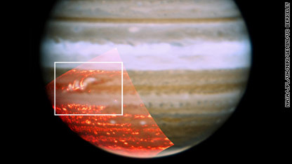
A three-color composite image shows a belt that had previously vanished in Jupiter's atmosphere is now getting a bit darker and seems to be reappearing.

One of Jupiter's stripes that "disappeared" last spring is reappearing and the disappearance was apparently an illusion created by Jupiter's atmosphere,NASA scientists said.

Scientists noticed earlier this year that the longstanding dark-brown stripe, called the South Equatorial Belt, had turned white, essentially disappearing. Researchers with NASA's Infrared Telescope Facility, the W.M. Keck Observatory and the Gemini Observatory telescope began studying the phenomenon and found the answer likely lies in a cloud deck made up of white ammonia ice that basically obscured the ring.

"The reason Jupiter seemed to 'lose' this band camouflaging itself among the surrounding white bands is that the usual downwelling winds that are dry and keep the region clear of clouds died down," said Glenn Orton, a scientist at the Jet Propulsion Laboratory. "One of the things we were looking for in the infrared was evidence that the darker material emerging to the west of the bright spot was actually the start of clearing in the cloud deck, and that is precisely what we saw."


Rare November tornadoes cause damage in Wis., Ill.

tornadox-large.jpg


MILWAUKEE (AP) — Cleanup from a rare November tornado begins Tuesday in southeastern Wisconsin.

A confirmed tornado touched down in Walworth County, where four homes and four farm buildings were damaged. The National Weather Service says the tornado was an EF-1 and traveled about four miles.

An apparent twister also moved through Union Grove in Racine County, where semis were blown over and debris was spread over parts of Interstate 94. The weather service planned to send a crew to Racine County Tuesday to confirm whether the storm was a tornado.

Utility outages were widespread late Monday afternoon, with some 42,200 customers without power from northern Winnebago County east to Belvidere, ComEd spokesman Paul Callighan said. The utility said the storms hit 10 transmission towers in Boone County.

The fast-moving storm system also produced two apparent tornado touchdowns in southeastern Wisconsin.

By Monday night, the storm front had moved eastward into Indiana and Michigan, but much of northeastern Illinois remained under flash flood watches and warnings from the heavy rain that accompanied the storms.


Strong winds blast East Coast, flip over planes


TRENTON, N.J. (AP) — Powerful winds knocked out power to nearly 12,500 customers and damaged some small airplanes in New Jersey early Wednesday.

Accuweather also warned of damage throughout Pennsylvania from the winds, which were expected to gust up to 45 miles per hour through tonight.

Thousands of customers are without power across Pennsylvania after a series of overnight rain storms accompanied by strong winds.

Peco said it has 17,000 customers without power Wednesday morning. Peco spokeswoman Karen Muldoon Geus says wind gusts forecast to reach 45 mph during the day has the utility on guard for more outages.

Monday, November 22, 2010

WA drought boosts snow in Antarctica


THE SIGNIFICANT DROUGHT IN southwest Australia may be linked to increased snowfall in the Antarctic over the past 30 years, researchers say. Understanding the connection could help farmers in Western Australia plan for years to come.

Analysis of ice cores, drilled at Law Dome just inland from Australia's Casey Station in the Antarctic, shows snowfall may be linked to climate in the Australian sector of the Southern Ocean and southwest WA.

Dr Tas van Ommen, principal research scientist with the Australian Antarctic Division in Hobart, presented his research results at Curtin University in Perth on Monday. He said the ice cores from the Law Dome site provided a record of annual snowfall variations stretching back over 750 years. And and over the past 30 years, the cores indicated there had been a significant increase in snowfall in that area, he said.

This was associated with significantly lower rainfall and subsequent drought in the southwest of Western Australia. "So when there's extra moisture at Law Dome, the same circulation pattern is starving Western Australia of moisture," Tas said.

Further work is underway to explore these connections and understand the reasons behind them, he added.

Electric Clouds


In a recent press release, scientists from the Weizmann Institute and the Goddard Space Flight Center announced that a mysterious zone of previously undiscovered particles fills the airspace around clouds.

Ilan Koren of the Weizmann Institute wrote: “The effects of this zone are not included in most computer models that estimate the impact of aerosols on climate. This could be one of the reasons why current measurements of this effect don’t match our model estimates.”

What appears to be clear blue sky around clouds, such as in the image above, is actually a region of particles that do not correspond to water vapor or the pollution-induced gasses that investigators expected to see. Since clouds have a high albedo and scatter polarized light from their outer margins, it is challenging for the MODIS research team to detect anything near them. So that glare from specular distortion does not obscure their results they avoid scanning an area about one kilometer distant from cloud boundaries.

Sunday, November 21, 2010

CONTRAILS

This is all you'll ever need to know:

Snow totals 11" in some parts of Mpls.-St. Paul area | Minneapolis and St. Paul | kare11.com

Snow totals 11" in some parts of Mpls.-St. Paul area | Minneapolis and St. Paul | kare11.com

Heart Attack Snow

The Scoop on Snow Shoveling Safety
It happens every winter in the Midwest ... snow falls, usually leaving piles of the stuff to clear from your sidewalks and driveway. Consider the following before you grab your shovel after a major snowfall.

The good news is that 15 minutes of snow shoveling counts as moderate physical activity according to the 1996 Surgeon General's Report on Physical Activity and Health. We all should aim for at least 30 minutes of moderate physical activity of some kind on most days of the week. Brisk walking or social dancing are other ways to fit in moderate physical activity during cold winter months.

The bad news is that researchers have reported an increase in the number of fatal heart attacks among snow shovelers after heavy snowfalls. This rise may be due to the sudden demand that shoveling places on an individual's heart. Snow shoveling may cause a quick increase in heart rate and blood pressure. One study determined that after only two minutes of shoveling, sedentary mens' heart rates rose to levels higher than those normally recommended during aerobic exercise.

Shoveling may be vigorous activity even for healthy college-aged students. A study performed by researchers at North Dakota State University determined that, based on heart rate, shoveling was a moderately intense activity for college-aged subjects most of the time but was vigorous activity during about one-third of their shoveling time of 14 minutes.

Shoveling can be made more difficult by the weather. Cold air makes it harder to work and breathe, which adds some extra strain on the body. There also is the risk for hypothermia, a decrease in body temperature, if one is not dressed correctly for the weather conditions.

Who should think twice about shoveling snow?

Those most at risk for a heart attack include:

  • Anyone who has already had a heart attack.
  • Individuals with a history of heart disease.
  • Those with high blood pressure or high cholesterol levels.
  • Smokers.
  • Individuals leading a sedentary lifestyle.

Should you rush out and buy a snow blower?

Not necessarily. Not everyone who shovels snow is going to have a heart attack. Snow shoveling can be good exercise when performed correctly and with safety in mind.

Also consider back safety when shoveling snow. Even if you exercise regularly and are not at risk for heart disease, shoveling improperly could lead to a strained back. If you've been inactive for months and have certain risk factors, use some common sense before taking on the task of snow shoveling.

A Pile of Snow Shoveling Tips

Be heart healthy and back friendly while shoveling this winter with these tips:

  • If you are inactive and have a history of heart trouble, talk to your doctor before you take on the task of shoveling snow.
  • Avoid caffeine or nicotine before beginning. These are stimulants, which may increase your heart rate and cause your blood vessels to constrict. This places extra stress on the heart.
  • Drink plenty of water. Dehydration is just as big an issue in cold winter months as it is in the summer.
  • Dress in several layers so you can remove a layer as needed.
  • Warm up your muscles before shoveling, by walking for a few minutes or marching in place. Stretch the muscles in your arms and legs, because warm muscles will work more efficiently and be less likely to be injured.
  • Pick the right shovel for you. A smaller blade will require you to lift less snow, putting less strain on your body.
  • Begin shoveling slowly to avoid placing a sudden demand on your heart. Pace yourself and take breaks as needed.
  • Protect your back from injury by lifting correctly.
  • Stand with your feet about hip width for balance and keep the shovel close to your body. Bend from the knees (not the back) and tighten your stomach muscles as you lift the snow. Avoid twisting movements. If you need to move the snow to one side reposition your feet to face the direction the snow will be going.
  • Most importantly — listen to your body. Stop if you feel pain!
http://www.ext.nodak.edu/snow.htm


Tuesday, November 16, 2010

Snowmageddon Makes the List

"A good newspaper," Arthur Miller observed in 1961, "is a nation talking to itself."
Nearly 50 years later, Miller's missive still rings true -- though now that we're no longer constricted to a once-a-day paper, the conversation's moving fast enough for us to need a list to help remember what was worth talking about in the first place. That's where the Global Language Monitor Survey comes in handy. The Texas-based survey uses a math formula to track the frequency of words and phrases in the English-speaking world of more than 1.58 billion people.


Remember good old H1N1? That topped the list in 2009, along with Twitter and Obama. Now swine flu is but a distant memory.
Let's hope the same can be said for this year's winner. One "spillcam" a generation is just fine by me.


Holding enough ice to raise sea levels by nearly 200 feet if it all melted, Antarctica is a major factor when it comes to climate change.


That's partly why NASA, yeah the space agency, also sponsors science here on Earth — and right now it's got several dozen scientists criss-crossing the western coast of the continent to measure sea ice and glaciers — the huge rivers of ice that hold back the two vast ice sheets covering Antarctica.


A DC-8 carrying seven instruments, and the researchers, has been making flights along Antarctica's west coast since Oct. 26 — and as weather conditions permit. Flying from a base in Punta Arenas, Chile, the mission hopes to have 11-12 flights completed before packing up on Sunday.

Our Weather Eye to the Sky


WALLOPS, Va. — It's an anonymous and secluded place from which to distribute satellite weather images watched by practically the whole world.


The Wallops Command and Data Acquisition Station, located near Chincoteague Island, is a vital link in the National Oceanic and Atmospheric Administration's mission to provide accurate weather data to the nation.


Passed by countless motorists every day, virtually everyone sees the results of the work that goes on there, in the form of the satellite images used in television weather broadcasts.

Monday, November 15, 2010

summer in retrospect

how warm was this summer

Let's look at the surface temperatures in the summer of 2010, which justifiably received a lot of attention. Figure 1 shows maps of the June-July-August temperature anomaly (relative to 1951-1980) in the GISS temperature analysis (described in paper in press at Rev. Geophys., available at this link) for 2009 and 2010, as well as maps for December-January-February (Northern Hemisphere winter, Southern Hemisphere summer) for the past two years.

June-July-August 2010 was the 4th warmest in the 131 year GISS analysis, while 2009 was the 2nd warmest1. 2010 was a bit cooler than 2009 mainly because a moderate El Nino in the equatorial Pacific Ocean during late 2009 and early 2010 has been replaced by a moderate La Nina. Also most of Antarctica was cool in winter 2010, while it was warm in 2009. Antarctic winter temperature anomalies are very noisy, fluctuating chaotically from year to year.

The maps make clear that perceptions of how hot it was depend on where you live. The two warmest anomalies on the planet this past summer were Eastern Europe and the Antarctic Peninsula. Not many people live on the Antarctic Peninsula and an anomaly of even several degrees in winter there is not a big deal. But the warm anomaly centered in Eastern Europe, which covered most of Europe and the Middle East, was noticed, to say the least. It was also quite warm in Japan, where the prior summer had been cooler than the 1951-1980 mean. The United States, which had been unusually cool in the summer of 2009, was warm this past summer, except the Pacific Northwest, which was cooler than the 1951-1980 climatology.

INDO-fltr-articleLarge.jpg

MAGUWOHARJO, Indonesia — A powerful overnight eruption of Mount Merapi created chaos for Indonesia’s disaster response effort on Friday after an explosion of hot gases and debris killed scores of people and sent more than 160,000 villagers fleeing to underprepared evacuation camps.

Heavy white ash covered the runways at the airport in nearby Yogyakarta, forcing it to close Friday, The Associated Press reported. It was not clear when it would reopen.

The latest, unexpected eruption prompted authorities to extend the evacuation radius around Mount Merapi to 20 kilometers, or 12.5 miles, from 15 kilometers. An earlier eruption the day before had caused it to be extended from an initial 10 kilometers.

Despite chaos as authorities abandoned previous havens, Mr. Nugroho said it was the right approach to keep evacuees so close to the erupting volcano.

With tens of thousands evacuating camps, and tens of thousands more abandoning villages, police, troops and aid workers struggled to deal with crowds at new collection points further away from the smoldering mountain.

Twin Cities Snowstorm Cuts Power, Triggers Car Accidents

Early Snow Stuns Twin Cities
This could go down as one of the most significant snowstorms to strike the Minneapolis/St. Paul metro area before the Thanksgiving holiday in two decades. The impacts were far reaching; from power outages to car accidents to flight cancellations.


The impacts were felt outside of Minnesota, as well. Two deaths from a car accident in Wisconsin are being blamed on the snowstorm.

Roughly 8 to 12 inches of heavy, wet snow has fallen over the Twin Cities since the snow began late Friday night.According to the Star Tribune, Greg Spoden at the Minnesota State Climate Office stated that this will probably be the biggest pre-Thanksgiving snowstorm for the Twin Cities since 1991, the year of the Halloween monster.

A storm system, which originated in the central Plains, intensified on Friday and into Saturday morning as it moved into Iowa and Wisconsin.


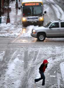
Snowy street in Minneapolis (AP photo)


Snow fell in earnest during the mid-morning hours over the Twin Cities metro area, at times at the rate of 1 inch per hour.

With a temperature hovering around the freezing mark, the snow that fell had a very high water content. This translates as a heavy snow that results in backbreaking shoveling, not the light and powdery kind.

The snow began to accumulate on tree branches and power lines and weighed them down considerably. The weighing of the snow led to the snapping of hundreds if not thousands of tree branches citywide, and power lines crashed to the ground.