13 December 2010 Last updated at 12:55 ET
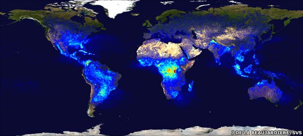
A US space agency lightning detector circles the Earth in a low-orbit. Its map of lightning frequency shows that places in Africa experience the greatest number of strikes
Cameras to detect lightning on Earth are to be placed high up in space by the US and Europe this decade.
Meteorological agencies already monitor lightning from the ground, and American instruments also fly in a low orbit.
But the addition of systems that sit and stare at the Earth from 36,000km should deliver a wealth of new data to improve warnings about imminent storms.
This will have key benefits for the aviation sector in particular, allowing it to route planes more safely.
"Lightning is a very good proxy for severe weather. In fact, it is a lead indicator - you often get lightning just before you get heavy rain, hail and even big gusts of wind," explained Dr Jochen Grandell from the European Organisation for the Exploitation of Meteorological Satellites (Eumetsat).
"For lightning safety as well - you can see active areas. Not all storms produce lightning and that is important information for aviation," he told BBC News.
Dr Grandell will be speaking this week at the American Geophysical Union (AGU) Fall Meeting, the largest gathering of Earth scientists in the world.
He will be describing the novel Lightning Imager that will go on Europe's next generation of Meteosats from late 2017. They will be the first geostationary spacecraft operated by Eumetsat to carry such an instrument. The Americans, too, plan lightning imagers for their Goes-R and Goes-S meteorological platforms.
The European imager, at a very basic level, is like a high-speed video camera. It will view the disc of the Earth from high above Africa, and stream information on lightning to weather forecasters in about a minute of discharges being detected. This will assist greatly with what meteorologists call "nowcasting" - the ability to make very short range, local forecasts of intense storm activity.
More than 2,000 thunderstorms are in play throughout the world at any one time, producing on the order of 100 flashes per second. Land areas get more lightning than the ocean, with tropical Africa experiencing the most strikes.
The Meteosat instrument will detect cloud-to-cloud and cloud-to-ground lightning. It will see the discharges as a rapid brightening of the cloud tops. This rather diffuse light, observed in the near-infrared, will give location information down to about 10km.
"We'll see not just the lightning in night-time conditions when you can imagine it's quite simple, but we'll also be seeing it in daylight when the cloud is illuminated by the Sun overhead. Technically, that's quite a challenge," said Dr Grandell.
Viewed from above the clouds by the shuttle, lightning appears as diffuse blobs
Meteorological agencies such as the British Met Office already use very effective ground systems to detect lightning. The UK has a system called ATDNet which senses a discharge from its radio frequency emission. Radars can also provide lightning information, and these are commonly used near airports to warn of approaching severe weather that might force authorities to divert or even ground planes.
The Eumetsat system in geostationary orbit will be complementary to the terrestrial systems, with one of the imager's major contributions expected to be the uniformity of its coverage - the idea that the one instrument sees lightning over the full disc of the Earth.
This will help climate researchers, for example, to develop very good statistics on the frequency of lightning over time.
"As soon as we have a number of years of data, we might be able to assess the impact of climate change on thunderstorm activity," said Dr Rolf Stuhlman, the Eumetsat MTG programme scientist.
Continue reading the main story
METEOSAT - BIGGER, BETTER
Europe's 1st Meteosat imaging spacecraft (800kg) was launched in 1977
Today, the 2-tonne Meteosat 8 & 9 spacecraft help produce Europe's forecasts
The planned 3rd generation imager will be a 3-tonne satellite; it should enter service in 2018
MTG (above) adds a second platform: a sounding satellite to sense the different atmospheric layers
Consortium wins big weather prize
"Climate is always something which is global and we will not be looking global, this is true. But there will be lightning imagers on the American Goes-R and Goes-S satellites, and there are plans also for Chinese geostationary satellites. So we can expect soon to have all these lightning imagers in the global agreement [on data sharing]."
Atmospheric chemists are also fascinated by lightning because its energy plays a significant role in turning the "unreactive" nitrogen in the air into the "reactive" forms such as nitrogen oxides. These can catalyse the production of ozone, which near the ground is an irritant to the human respiratory system and is damaging to plant health.
And another potential benefit would be in helping to improve the models used to forecast where forest fires might start as a result of lightning strikes.
The 3.4bn-euro (£2.8bn) Meteosat Third Generation (MTG) project is one of the most complex space endeavours ever undertaken in Europe.
Its suite of instruments spread across two satellite platforms should bring a step change in capability.
When the operational system is in place, it will be delivering something like 250-300Mbps of data to Eumetsat headquarters in Darmstadt, Germany. That information then has to be processed and distributed to the continent's national meteorological agencies so they can produce constantly updated forecasts for their citizens.
Jonathan.Amos-INTERNET@bbc.co.uk
No comments:
Post a Comment